HISTORY, CIVICS AND GEOGRAPHY
Paper 2 (Geography)
(Two hours)
Answers to this Paper must be written on the paper provided separately.
You will not be allowed to write during the first 15 minutes.
This time is to be spent in reading the question paper.
The time given at the head of this Paper is the time allowed for writing the answers.
Attempt seven questions in all.
Part I is compulsory. All questions from Part I are to be attempted.
A total of five questions are to be attempted from Part II.
The intended marks for questions or parts of questions are given in brackets [ ].
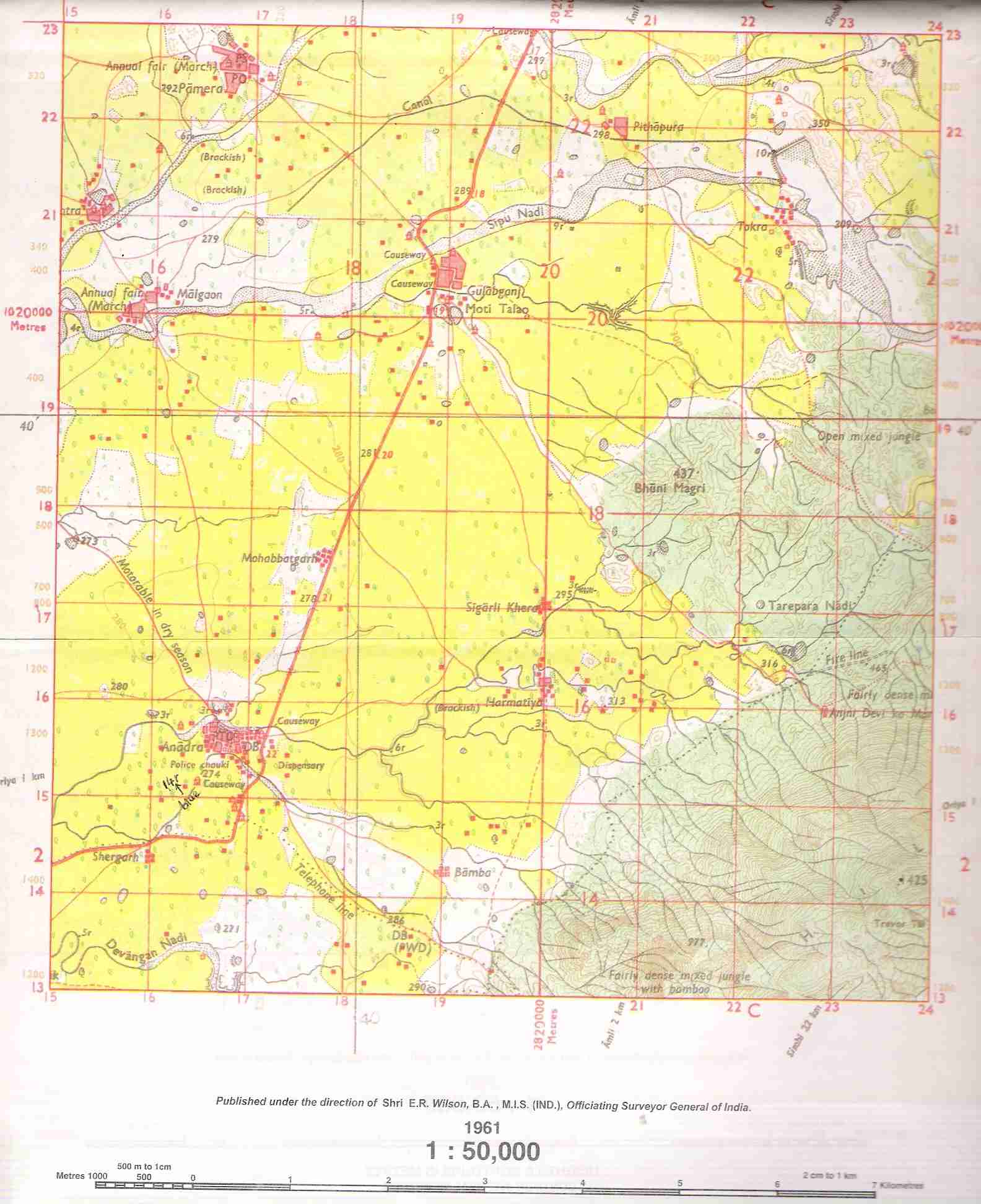
To be supplied with this Paper: Survey of India Map Sheet No. 45D/10
and 20 cm of twine.
Note:-
(i)
In all Map Work, by a wise use of arrows to indicate positions of
countries, cities and other insertions that you make, you will be able
to avoid overcrowding parts of the map.
(ii) The extract
of Survey of India Map Sheet No. 45 D/ I0 must not be taken out of the
examination hall. It must be handed over to the Supervising Examiner on
the completion of the Paper.
(iii) The Map given at the end of this question paper must be fastened with your answer booklet.
(iv) All sub-sections of each question must be answered in the correct order.
(v) AII working including rough work should be done on the same answer sheet as the rest of the answer.
PART I (30 Marks)
Attempt all questions from this Part
|
Question 1 Study the extract of the Survey of India Map sheet No. 45D/10 and answer the following questions: Click here for Survey of India Map sheet No. 45D/10. |
| (a) What is the compass direction of Sunset point from the settlement of Anadra? | [1] |
| (b) What is the pattern of drainage in grid square 2315? | [1] |
| (c) Mention any two features seen in the map extract which indicate that the region has seasonal rainfall. | [1] |
| (d) Calculate the distance in kilometers along the metalled road from causeway in grid square l715 to the distance stone marked 20 in grid square l8l8. | [1] |
| (e) What advantage does a Representative Fraction have over a verbal scale? | [1] |
|
Question 1 (f) Give the six figure grid reference of: |
(i) Anjini Devi ka Mandir
(ii) Δ 1327.
| Question 1 |
| (g) Name the three different kinds of roads in grid square 2411 grid square 2515. | [2] |
| (h) Mention two occupations of the people living in the northern part of the region in the map extract. Give reasons to support your answer. | [2] |
| (i) What is the difference between the slope in grid square 2115 and the one in l8l1. Give a reason for your answer. | [2] |
|
Question 1 (j) What is the purpose of: |
(i) the fireline in grid square 2316.
(ii) the pipeline in grid square 2209?
|
Question 1 (k) What do the following represent? |
(i) The red square in grid square 2514.
(ii) 4r in grid square 1612.
| Question 1 |
| (l) Abu is a popular holiday resort. Mention any three features seen in the map extract which attract holiday makers to Abu. | [3] |
|
Question 2 On the outline map of South Asia provided: |
| (a) Label the river Sutlej. | [1] |
| (b) Label the river Godavari. | [1] |
| (c) Mark with a bold line and name the Aravali Range. | [1] |
| (d) Mark and label the Khyber pass. | [1] |
| (e) Mark and name the largest commercial city of Pakistan. | [1] |
| (f) Mark and label Bangalore. | [1] |
| (g) Shade and label an area of laterite soil in North India. | [1] |
| (h) Mark and name an off shore oil field. | [1] |
| (i) Mark and label the Tropic of Cancer. | [1] |
| (j) Mark and name the winds which bring rain to Bangladesh in July and August. | [1] |
PART II (50 Marks)
Attempt any five questions from this Part.
| Question 3 |
| (a) Mention two favourable effects of the Himalayas on the economy of India. | [2] |
| (b) Why is Pakistan often described as the 'Gift of the Indus'? Give two reasons. | [2] |
| (c) Mention three differences between the Western Ghats and the Eastern Ghats. | [3] |
| (d) Give three reasons why Bangladesh is one of the most densely populated countries in the world. | [3] |
| Question 4 |
| (a) What is the latitudinal and longitudinal extent of Pakistan? | [2] |
| (b) Mention two factors which are responsible for the slow growth of industry in Nepal. | [2] |
| (c) Mention three benefits of the long coastline of India. | [3] |
|
Question 4 (d) Give reasons for the following: |
(i) The Deccan plateau is a highly dissected one.
(ii) Most of the rivers in South India flow into the Bay of Bengal.
(iii) The Rann of Kutch is not cultivated.
| Question 5 |
| (a) Mention two differences between the cyclonic rain in Bangladesh and the cyclonic rain in Pakistan. | [2] |
| (b) Name the source of winter rain in Tamil Nadu. How does Tamil Nadu benefit from it? | [2] |
|
Question 5 (c) Give a reason for each of the following: |
(i) Patna gets a heavier rainfall than Varanasi.
(ii) The Arabian Sea branch of the South West Monsoon does not shed any moisture in Western Rajasthan.
(iii) India has varied climatic conditions.
|
Question 5 (d) Study the climatic data provided below and answer the questions that follow:
|
(i)Calculate the annual range of temperature of Station A. Suggest reason why the range is a small one.
(ii)Which of the two Stations has the lower temperature? Why?
(iii) Calculate the annual rainfall of Station B.
| Question 6 |
| (a) Explain the formation of Laterite soil. Why is Laterite soil not suitable for cultivation? | [2] |
|
Question 6 (b) Give one difference between the following: |
(i) Khadar soil and Bhangar soil.
(ii) Sheet erosion and Wind erosion.
| Question 6 |
(c) Mention two characteristics of Black soil. Why is this soil agriculturally important?
|
Question 6 (d) Give reasons as to why: |
(i) Red soil is red in colour.
(ii) Large tracts in Maharashtra are covered with Black soil.
(iii) Man is largely responsible for soil erosion.
| Question 7 |
| (a) Name two states with large deposits of coal. Name the coalfields in the states that you have named. | [2] |
| (b) What is lignite? Name one place in India where it is mined. | [2] |
| Question 7 |
(c) (i) Mention two uses of mineral oil.
(ii) Name an old and a new mineral oil producing area.
| Question 7 |
(d) (i) Mention two reasons why minerals are important?
(ii) Name one area in Orissa and one area in Chattisgarh where iron ore is mined.
| Question 8 |
(a) (i) When are kharif crops (l) sown and (2) harvested?
(ii) Name a cash crop which is also a kharif crop.
| Question 8 |
(b) India is the largest producer of tea. State the climatic factors necessary for its growth.
|
Question 8 (c) Explain the following methods of propagation and name the crop associated with each: |
(i) bud grafting
(ii) ratoon cropping
| Question 8 |
(d) (i) What are the geographical conditions necessary for the cultivation of groundnuts?
(ii) What climatic condition adversely affects the groundnut crop?
(iii) Name two non-edible oilseeds grown.
| Question 9 |
| (a) What are two advantages of natural gas? | [2] |
| (b) Mention two reasons to explain the increasing use of bio-gas. | [2] |
| (c) Give three reasons to explain why it is easier to harness rivers in South India for power than rivers in North India. | [3] |
| Question 9 |
(d) (i) What does NTPC stand for? Mention one of its functions.
(ii) Name any two coal based thermal power stations in Uttar Pradesh.
| Question 10 |
| (a) Mention two reasons why the sugar industry has developed in Maharashtra. | [2] |
| (b) Give two reasons for the importance of the silk industry in India. | [2] |
| (c) Give three factors that favour the cotton industry in Kolkata. | [3] |
| Question 10 |
(d) (i) Explain why sugar-cane must be crushed within 24 hours of harvesting.
(ii) Name four sugar milling centres in the northern plains.
| Question 11 |
| (a) Mention two reasons for the importance of the Electronic industry in India's development. | [2] |
| (b) What is a petrochemical industry? Mention two reasons why petrochemical products are replacing traditional raw materials. | [2] |
| Question 11 |
(c) (i) Mention two characteristics of a mini steel plant.
(ii) From where does the integrated steel plant at Jamshedpur get its iron ore and coal?
|
Question 11 (d) Name the following: |
(i) A shipbuilding yard on the west coast of India.
(ii) A centre where diesel locomotives are manufactured.
(iii) The foreign collaborator of the iron and steel plant at Rourkela.